Continuous monitoring for dams, slopes, and high-risk geotechnical structures.

Volumetric coverage (3D)

Continuous Time-lapse monitoring (4D)

Predictive intelligence

The blind spots in traditional monitoring
Point sensors such as piezometers and inclinometers provide precise data at their installation points, but they often fail to capture the full spatial complexity of subsurface hydrological behavior.
Reactive vs. Proactive: Inclinometers and Total Stations are “Lag Indicators”—they often detect movement only after deformation has already started.
The Invasive Risk: Manual data collection adds cost and delays, and installing additional sensors can require invasive drilling on unstable structures.
Bottom line: You can’t manage what you can’t see between the sensors.
Inside-out visibility
LiDAR maps the surface (outside). Geophysics maps the interior (inside).
We don’t replace your existing instrumentation; we make it spatially relevant. By fusing surface topography with subsurface imaging, we create a complete, repeatable picture of your asset’s health.
Outside (The Skin): Drone LiDAR penetrates vegetation to map the true ground surface with sub-centimeter accuracy.
Inside (The Organs): Automated Electrical Geophysics (AEG) scans the entire volume of the structure to map resistivity and chargeability.
How It Works

Automated Electrical Geophysics (AEG)
We convert traditional geophysical surveys into a fixed, automated monitoring system that sees what point sensors miss.
Non-Invasive Installation
We install fixed surface electrode arrays that scan the internal structure without the risks or costs associated with invasive drilling.
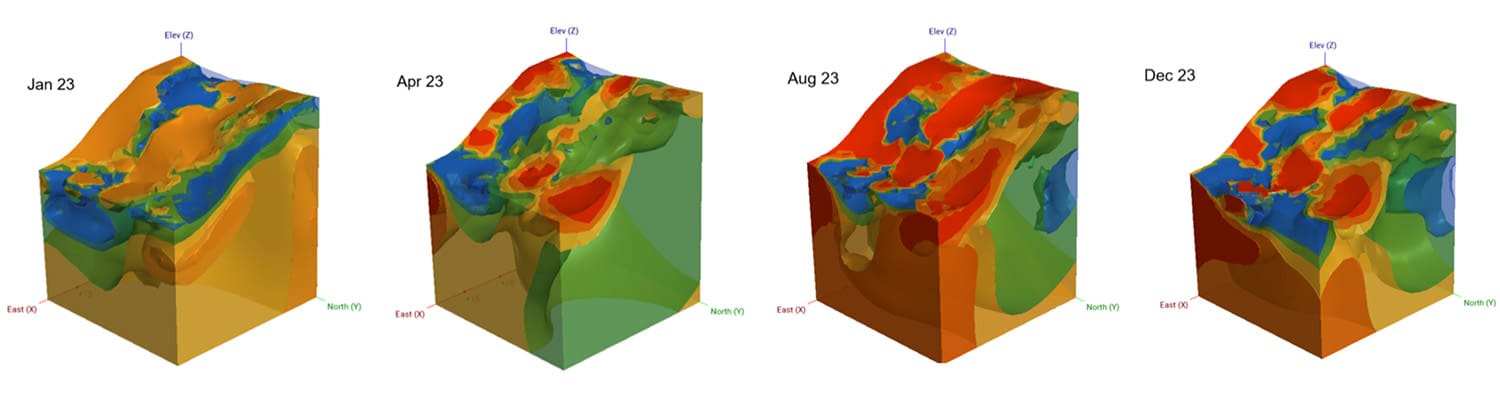
Volumetric 3D Scanning
Unlike piezometers that only measure a vertical line (1D), our system scans the entire volume of the dam. This fills the critical gaps between sensors to detect hydrological features and internal erosion paths.
Predictive 4D Intelligence
By integrating real-time rainfall data, our AI models analyze how internal moisture plumes evolve over time. This allows us to identify saturation spikes days before they manifest as physical deformation.

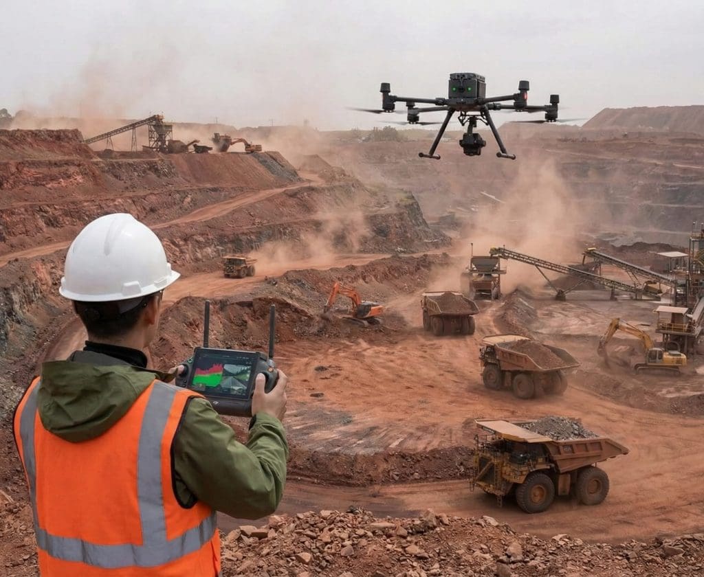
DRONE
LiDAR
We replace manual, risky topographic surveys with fully autonomous aerial inspections.
Penetrates Vegetation
Utilizing the Zenmuse L2 sensor, our drones see through dense canopy to map the true ground surface with millimetric precision, ensuring your “As-Is” or “As-Buit” geometry is accurate regardless of overgrowth.
24/7 Autonomous Patrols
Supported by “drone-in-a-box” stations (DJI Dock), our systems conduct scheduled inspections day and night. This removes operators from hazardous zones and ensures continuous monitoring even during storm events.
Standardized Repeatability
Automated flight paths ensure every inspection captures the exact same data points, creating a consistent historical record for audit trails.
Earlier warning from synchronized subsurface models & rainfall
In field data, the 3D models tracked rainfall patterns, and the system identified saturation spikes days before traditional sensors.
Built for modern monitoring requirements
We support continuous monitoring programs and help teams address compliance gaps tied to Agência Nacional de Mineração (ANM) regulations, including ANM 220/2025.
Mandatory Automation
Meet the automation requirements for high-risk dams (DPA ≥ 4) without manual data collection.
The "As-Is" Requirement
For pre-2010 dams lacking “As-Built” plans, we map internal zoning and geometry non-invasively, satisfying Article 34 without dangerous drilling.
24/7 Remote Operations
Utilizing “Drone-in-a-Box” (DJI Dock), we support continuous monitoring even during storms or night shifts, keeping your team out of harm’s way.
Technical Comparison:
Why Add Mogo to Your Monitoring Plan?
Feature
Piezometers (Traditional)
Mogo Auto-Geophysics
Data Type
Timing
Blind Spots
Installation
Why Mogo? ROI beyond safety

Premium partnership

Proven ROI

Predictive insight

Full lifecycle support
Request A Demo
Contact Us
See how Mogo can improve safety, strengthen compliance, and save costs at your sites. Contact us to set up a call and see if we are a fit.